We started at Main City Park in Gresham. Normally that would give us a car free 5 mile ride on the Springwater Corridor to end the ride, always nice if it ends up dark. Today, because of predicted wind direction, and more so because of the predicted 90 degree temps, we rode the opposite way around. This would put the lion's share of the climbing at the very beginning of the ride when it was cool. We would have 7500 ft of climbing in the first 50 miles.
It was cool, in the low 50's, as we pedaled out at 7AM. I had arm and leg warmers on, as well as a light windbreaker. John had bare arms and legs, and was feeling the cold as we pedaled to Boring.
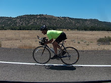
As we pedaled toward Sandy we had the rising sun straight in our faces. John was dressed in all black and virtually disappeared in the glare. A vehicle even stopped to tell him that he couldn't see him until he was next to him. I had my rear blinky on. John didn't have a back light. He ended up putting his front blinky on the drops facing backward. It was a good move, I couldn't see him, but could see that light. We were happy when the sun got higher in the sky, and our direction changed slightly.
Once in Sandy I took every available opportunity to ride parallel routes. Highway 26 can be such a slog. I took Waggoner Loop which is just a short section with some homes nestled in the trees.
I also took Cherryville Rd. It was a nice respite from the busy Highway 26 that lasted for several miles.


John was waiting for me at the bridge over the Sandy River. He said he was going to ride on ahead so that he could ride bonus miles/bonus elevation up to Timberline Lodge. I was going to be satisfied just to ride around Mt Hood today! We would meet at the intersection of Timberline Rd and Hwy 26.
As I rejoined Hwy 26 I stopped at the ZigZag Mtn Cafe, and had a piece of blackberry cobbler that I had been jonesing for.
I rode Kiwanis Camp Rd.

I got back on Hwy 26 and rode to Government Camp, where I got a chocolate milk and refilled water bottles.
John was waiting for me at Timberline Rd.
We rolled down toward the White River.

The is virtually no snow on Mt Hood this year. The only white on the mountain is glacial ice. We arrived at White River.

The river was running low, but heavy with silt and glacier flour.

Once at White River, we began the climb to our high point of the day, 4659 ft Bennett Pass.
The fall colors we beginning to show as we gained elevation.

Mt Hood loomed large as we made our way up Bennett Pass.

The day was beginning to warm up as we summited Bennett Pass. We were happy that the bulk of our climbing was over. We took the fun descent down Highway 35 toward Hood River. We exited Hwy 35 after 17 miles. We continued rolling down through the Hood River Valley. We stopped in Parkdale. I had another chocolate milk, and an ice cream sandwich!
We took the Dee Highway down through the Valley. It was scenic, but gave us bonus climbing as we'd make our way over small hills in the valley. Hwy 35 would have been all down hill, but not nearly as pretty!
We got to Hood River and refilled water bottles, adding some ice to them.
As we pedaled out another of our old college room mates, Terry, happened to be driving along and recognized us. He shouted out, we stopped, he turned around. We visited for maybe 15 minutes.

We still had about 60 miles to go, and darkness would be arriving in about 3 hours, so we bid adieu, and pedaled on. As we pedaled, John and I remarked on what was the chance that Terry would happen to be on that same short section of road (maybe 10 blocks) AND recognize us!
We were soon on the shoulder of I-84 and riding the 10 miles necessary to access the Historic Columbia River Hwy/State Trail. Luckily, the road evidently has been swept since I rode here a few weeks ago.
We took Herman Creek Rd. It gave us another bonus climb, this one being our steepest of the day, hitting 13%. It had also been very recently chip sealed. The oil made the rock chips stick to our tires and it was jamming between the fork and tire. Looking back, we decided that this was not our best move.
Darkness was approaching. I had a good headlight, two tail lights, all sort of reflectivity on the bike and me. John wasn't nearly as prepared. He put some distance on me. I was hoping that he'd push on and get back to Gresham before darkness if he was able. Though I was trying somewhat to make time, I did keep an eye out for photo opportunities.
 |
| Oneonta Tunnel |
The shadows were getting long. I turned on my rear blinky as I climbed up to the Vista House. When I got there I made a loop through the parking lot to see if John was there. I was hoping that he wasn't. The place was packed with people with cameras, waiting for what promised to be a great sunset shot. I didn't take time to wait and take a photo, I climbed up to Women's Forum Park, the high point of this last real climb. I made a loop through that parking lot as well. I figured that if he was going to wait for me, it would be here. I was glad to not find him there. I put on my front light before taking the descent.
I rolled down to the Sandy River and crossed the Stark Street Bridge. I had mapped low traffic volume roads for the final few miles into Gresham, just in case we got into darkness. John did not have the benefit of that route, but knows that area.
As I arrived at Main City Park at 8:30PM, John was standing near my pickup. He said that he didn't make it back before dark but didn't have any issues. He noted that he made the climb to Vista House in 10 minutes, I had taken nearly 30 minutes to do it. Of course I stopped to take this photo.

We were both tired and hungry. By the time we got out of bike shoes and got the bikes loaded it was just before 9 PM. After our first choices we closing for the night, we settled on a ale house/restaurant in the area. We had an adult beverage and nachos.
It was a good way to end a good ride.

.......Road bike........Rollers.......MTB.......Lifecycle....Total
Today.......145...............0..............0..............0..............145
Jan..........765.............0..............0..............0.............765
Feb..........248............0..............0..............0..............248
March......183...........0...............0.............0...............183
April........228...........0...............0.............0...............228
May.........200............0..............0.............0...............200
June.........199...........0...............26...........0...............225
July..........246...........0...............0.............0...............246
August.....502...........0...............0.............0...............502
Sept...........391...........0...............0.............0................391
Total........2962.........0...............26............0..............2988


No comments:
Post a Comment
Thanks for taking the time to leave a comment.