 |
| There is another row of hills behind that this one, hiding in the bajareque. |

The town of Boquete was in sunshine, but Volcan Baru was shrouded in bajareque. I was going the opposite direction, but up to the same altitude. I figured if it was raining too hard I'd just turn around and skiddadle back down the hill.

I took the first left, on a rock road that cut across the hillside. I knew that it connected to a paved road that would bring me back to this point after bit of climbing up the hill.
I came across a tree that I could not identify. Any silvaculturists among my readers?


I continued up.

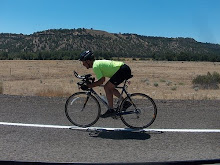
One thing about a slow uphill slog, one sees things that might otherwise be missed.

I had passed a sign in Spanish that said they used (brand name) fertilizer to increase production. I presume it increased production, it certainly made for healthy looking plants.

By the time I figured that I should have taken a photo of the sign, I was already beyond the point of being willing to turn around and go back down, only to have to pedal back up again. I continued upward.

It was steeper than I had remembered from the one time I rode down this. In this section I climbed 1200 ft in 1.5 miles. Not a typo. The bajareque was coming down.
I was starting to get a few drops of rain. I continue riding up.
I got to Alto Jamarillo.

The hills are steep enough that even the roads have problems hanging on. Here they are repairing a road that has slid into the canyon.

In these hills they grow some of the most expensive coffee on earth. The Geisha variety, grown on this farm sold for $300/lb at a wholesale auction.

By this time it was raining hard enough that I stopped and put on my windbreaker.
Even out this distance from town, it is not uncommon to see people on foot. Here a dad and his son move a hog along the road. I'm not sure where they were taking him, and the pig might not have known either.

I had crossed the high point of today's ride (5137ft) and would now be going downward.
I got to Alto Jamarillo Primary School and turned right.

Before too long I had a view of Boquete again. About at this point I had dropped below the rain, or moved around it.

I rolled by El Parador, but did not stop for a photo this time.
I ended up with 8.8 miles and 1739 ft of elevation gain. Not bad for the total, but like I said, 2/3 of that elevation gain came in 1.5 miles!


If you want to see the route on Google Earth, click HERE.
If you like the Google Earth option let me know. It only takes a few minutes to add, but if nobody uses it, I won't waste my time.
........Road Bike........Rollers.......MTB..........Lifecycle......Total
Today ......0.................0..................9....................0............9
Jan.........26................ 0................0.....................0..............26
Feb.........7..................0................0.....................0...............7
March.......5.................0................0.....................0...............5
April.......0.................0...............66.....................0...............66
May.........0..................0..............69......................0...............69
YTD.........38...............0...............141.....................0.............179


No comments:
Post a Comment
Thanks for taking the time to leave a comment.